Federal Mining Claims are granted to US Citizens for the purpose of extracting the minerals for commercial gain. Rockhounding does not require a mining claim, however Rockhounds cannot mineral trespass on active mining claims.
The BLM’s Guide to Rockhounding is helpful for defining the general rules and responsibilities for Rockhounding. The BLM’s Guide to Mining Claims defines the claim owner’s responsibility to clearly mark their claim so that Rockhounds have the ability to know where they can dig. As part of maintaining a claim, the claim owner has to agree to erect corner posts/markings on the claim site:
The undersigned testifies all monuments required by law were erected upon the subject claim(s), and all notices required by law were posted on the subject claim(s) or copies thereof were in place, and at said date, each corner monument bore or contained markings sufficient to appropriately designate the corner of the claim to which it pertains and the name of the claim(s).
Note that a mining claim only grants mineral rights to the claim owner, it still is public land and unless there are dangers (which will be clearly marked) citizens still can use our land.
In my prospecting I have seen several types of markings for Federal Mining Claims. As a rockhound I appreciate when the claim owner posts documentation on each of the corner posts with GPS coordinates so I can quickly identify the claim boundaries in my GPS unit. I appreciate when on the road into the claim or near pits/digs there is an obvious posting on a tree stating that the area is claimed. I’ve seen center/side posts erected which is helpful too! The easier the claim owner makes it to let the Rockhound know where the claim is the easier it is to not have accidents.
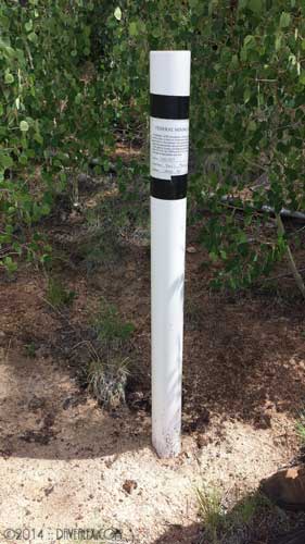
That said, I know that many times claim markers are tampered with, sometimes completely removed. I have talked with many claim owners that have to deal with marking their claims over and over again because the markers are removed or vandalized. Thus, I have learned how to do a little extra research before I head out to help me know when there are claims in the area that I will be prospecting.
When prospecting an area I always look for claim markers and signs, and if I find a place I want to get serious about digging I typically pull off the pack and take a walk around looking for corner posts in one direction. A little internet research ahead of time will also help in knowing how much hiking I want to do to ensure I’m not on a claim.
The BLM provides Federal Mining Claim information online for free at LR 2000 website. If you look at the BLM Mining Claim packet, and their online help, they recommend to use the Pub MC (Mining Claim) Geo Report. This report requires that you know a little bit about the area you want to search, specifically the MTR or Meridian Township Range, the Administration State, and the Case Disposition (Active, Closed, etc). So as an example, I will show how I would identify active claims at one of my favorite areas in Colorado, Devils Head.
For this example, I already know the Administration State (Colorado) and Case Disposition (Active), but I need to find the MTR(s) that I want to research. I do this by visiting another BLM site GeoCommunicator. From the menu on the left side of the webpage I choose Interactive Maps and then All Layers. A map displays allowing me to drill into the area I am interested in. I then use the toolbar to choose the Identify option.

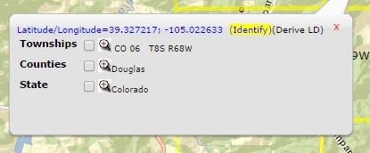
Then I click on the map to identify the Township where I’m interested in. You can click the checkbox in the information box and it will outline the entire township visually.
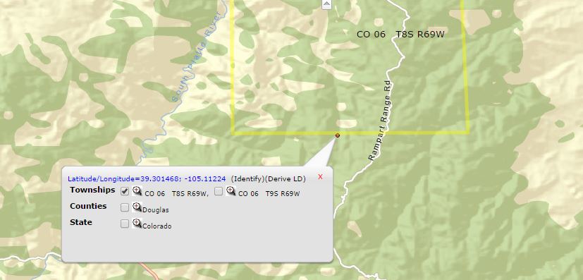
I then repeat for as many townships as I want to research in the LR2000 database.
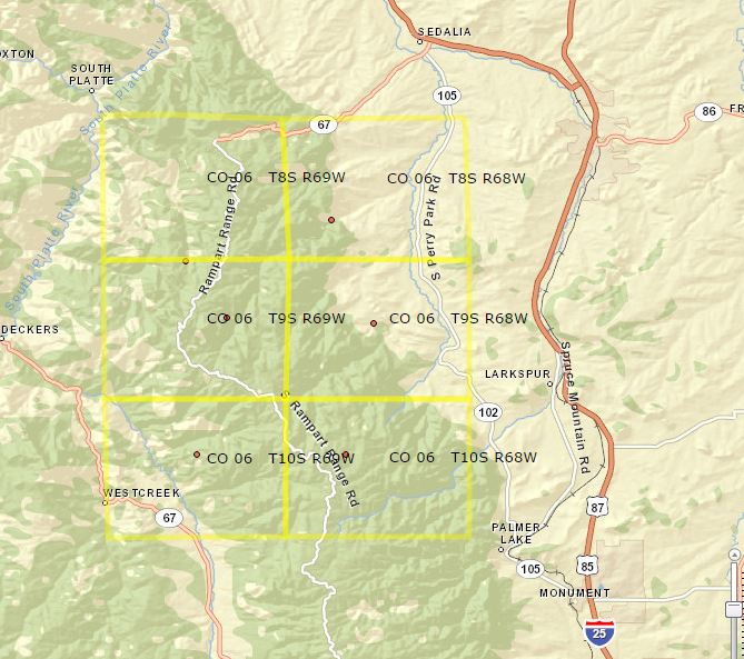
Now I have 6 townships that I want to research identified. The format is (for example the lower left):
- State: CO
- Meridian: 06
- Township: 10 South
- Range: 69 West
Now I can enter the required fields in the Pub MC Geo Report on the LR 2000 website. The first thing I do on the LR2000 Reporting website is to select the criteria I want to use. Obviously you don’t get a choice with State and Case Disposition, but for the other required field I choose MTR (Meridian, Township & Range) and then click the Select Criteria button.
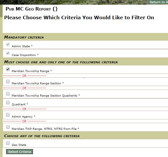
Click the Set button to set each of the criteria. For the MTR, you use the drop-down to select Meridian (06 – 6th PM) and then enter your Township (plus direction from the list) and Range (plus the direction from the list) and click the Add to MTR List button. Do this for each of the MTRs you want to research, in my case I chose all six I found on the GeoCommunicator site. NOTE, if you want to select multiple dispositions (for example, active and closed, hold the CTRL key and click all the options you want).
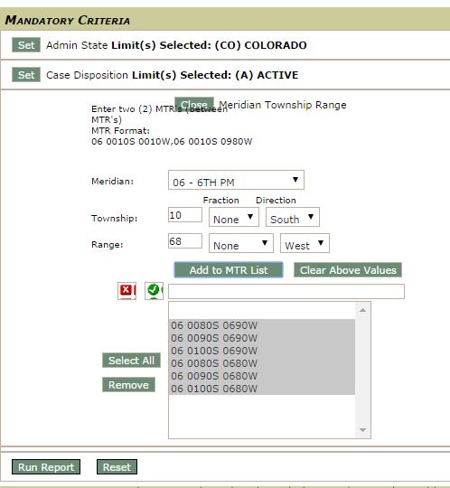
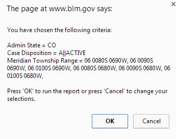
Now it is time to run the report by clicking the Run Report button. I have noticed you may have to click it again if the pop-up window does not show up. NOTE that this site uses pop-ups, so ensure that your pop-up blocker doesn’t suppress the report output window!!! You will see a pop up with all your selected criteria and then another window will appear with all the claims in the area.
The output doesn’t tell you the GPS coordinates of the claim, but it will tell you the Section and Subdivision along with the claim’s details including MTRS, name, serial number and information about the claim holder. If you refer back to the GeoCommunicator website, the identify information “window” will let you drill into detailed information that will say what Section (the ‘S’ in MTRS) your identified point is in.

As far as I have found, this is as detailed as you can get, but it will get you in the ballpark of where the claim(s) exists; and then you can visit the area in person and identify the claim by the corner posts that should clearly identify the claim name and which corner post you are looking at.
Please comment if you have other useful ways to identify federal mining claims. Happy Rockhounding!

Nicely done on how to do claim research! I would add one more step if you are looking for unclaimed ground in a section full of claims. Go to the BLM office at Youngfield Street and either pull up the claim numbers from the computers there or preresearch the numbers of active claims at home before you go there. At the office you can look at the actual claim papers from the numbers you got and hopefully find the bearing point or monument from where the corners are located. With enough work you should be able to plot a map of all the boundaries in that section before you even go. GeoCommunicator used to do that for you but it wasn’t up to date and probably had errors.
A lot of people have active claims but the markers can be tough to find especially if they use a stone pile or a tree with no tape around the papers. Mt Antero has quite a few stone piles for boundaries. At Spruce Grove someone used a film canister mounted on top of a metal barb wire fence post. Once a claim is not renewed, the corners should be removed but isn’t always done.
Thanks James. You were the one who inspired me to figure this out and gave me some good tips. I appreciate it!
Great info! Don’t know how you find the time to do these posts and get out there too! Thanks for your input it has been priceless. Jean and I have rockhounded down log jump several times and always come away with something. Can you explain the difference in”Active” and “Closed” claims? A website called “The Diggings.com” lists claims as such with the owners name still attached to the closed claims. Does “Closed” mean open to public? I assume not, I don’t understand the meaning of “Closed”. Any info would be appreciated.
Mike Rose
Hi Mike.
Here is a more recent blog post on specifically Devilshead. https://davealex.com/earthfire/finding-devils-head-claims/
If the BLM says the CMC# is closed, then it is no longer claimed; but remember that the LR2000 (and thus sites using that data stream like Diggings.com) are likely delayed and there could be another claim in progress. Remember the process, we’re dealing with government after all! First the miner is to mark the discovery point, then file a Location Certificate with the County, then file with the BLM, then wait for the paperwork to be done and a CMC# to be generated, then wait for the LR2000 and county’s Recorders office paperwork to be synced up; so there is a lag time in the process you need to be aware of that could easily span months if not longer!
I went up to the Devils Head area with the Lake George club last week and couldn’t find corner posts for many of the new claims…although I didn’t spend a ton of time looking; so they may be there, or maybe not.
Some say it’s the miner’s responsibility to post the claims and if they ain’t posted then it is fair game and not a valid claim. The government says that the Rockhounder should know where claims are so they don’t mineral trespass. There appears to be gray area here; so regardless I try to do my homework since that is the safest route for all.
I’m glad you are having fun and finding stuff out there! That is what this is all about (at least for me)!